Spain was hit by heavy rainfall in the last few days of October, which flooded entire regions in the east and south of the country. Rivers swelled and roads turned into rivers. The masses of water swept away cars, trees and parts of houses, among other things. Locally, thunderstorms with hail intensified the damage.
The region around Valencia was particularly affected, where most of the more than 200 people who have since died have been reported. Roads are still closed, railway lines are out of service and people are still missing in many places.
How did this extreme rainfall come about?
Trigger: cut-off low – a drop of cold air
To equalise temperature differences between the warm subtropics and the cold polar regions, there is a constant exchange of air masses in the atmosphere. This takes place in high- and low-pressure areas, in which the air is not only swirled horizontally but also vertically.
In the transition zone between warm air in the south and cold air in the north, the jet stream is found in the free atmosphere above 5 km, a band of strong winds that occasionally extends far to the south. The resulting low-pressure trough is filled with cold air from the north, which passes over very warm land and water on its way towards the subtropics, especially in autumn.
Neighbouring areas of high pressure often separate an independent low filled with cold air from this trough, the so-called cold air drop. This process is known as a ‘cut-off’. In Spain, this is known as ‘gota fría’ (=‘cold drop’) or ‘Dana’, an abbreviation for ‘depresión aislada en niveles altos’ (‘isolated low in high layers’).
Cut-off on 25 October 2024 – and the disaster began
The low pressure trough around which the jet stream ran on 24 October 2024, 00 UTC, at the 500 hPa level from Greenland to the 40th parallel north, has split off into an independent high pressure trough in the southern part: a cold air drop.
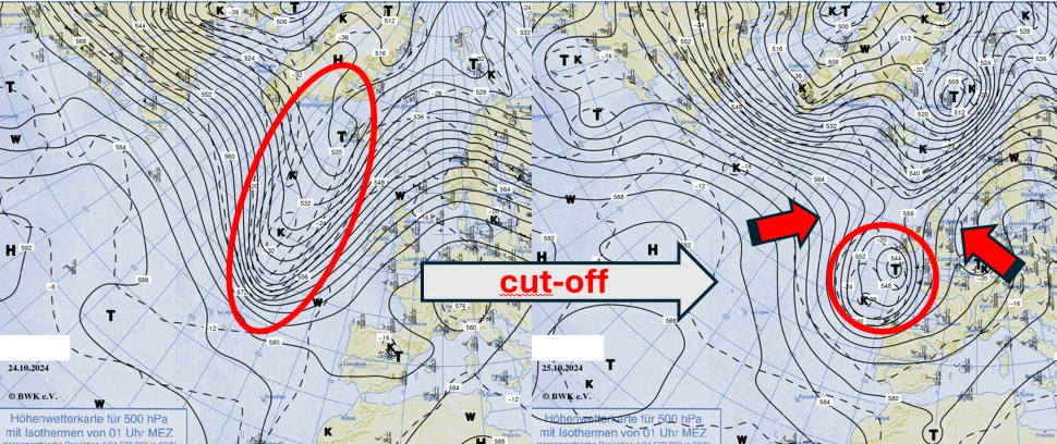
An independent low pressure system emerges from a trough, 500 hPa analysis map, 24 and 25 October 2024, 00 UTC (source: Berliner Wetterkarte)
This low-pressure system moved further south and remained active over south-west Europe for several days.
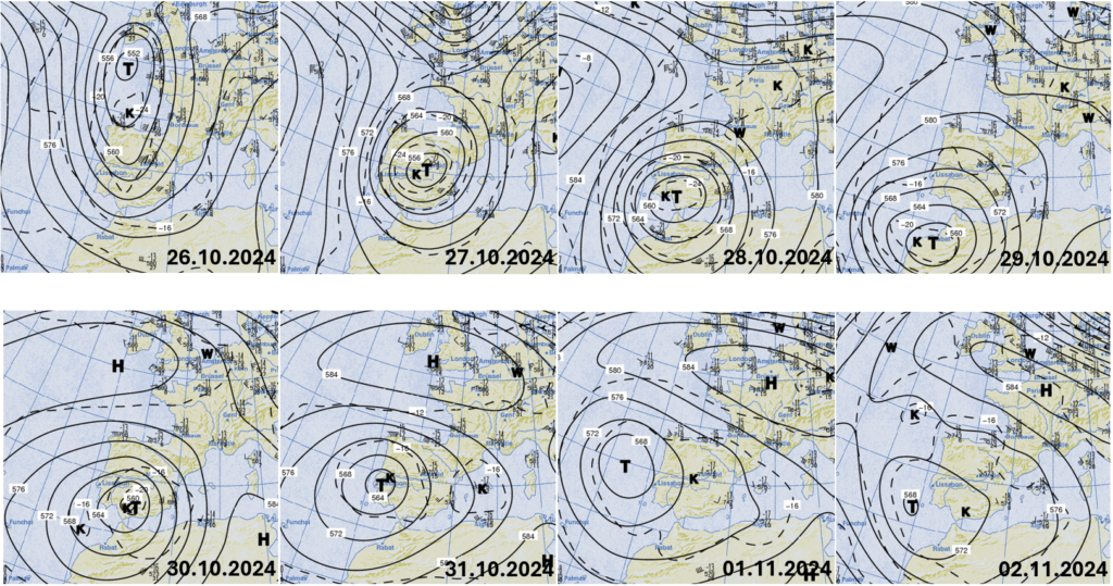
Position of the cut-off low (high altitude low) at 500 hPa level, 26 October 2024 to 2 November 2024, 00 UTC in each case (source: Berliner Wetterkarte)
Where temperatures of around -15°C were initially measured at an altitude of around 5.5 kilometres, cold air spread with temperatures below -20°C, in some cases below -25°C. At ground level, however, it was almost summer. At ground level, however, it was still almost summer, with stations in large parts of Spain reporting maximum temperatures of 20°C and in some cases over 25°C on 24 October. And off the east coast of the country, the Mediterranean Sea also reached water temperatures of 20 to 23°C at the surface.
Warm at the bottom, cold at the top – what does that mean in the atmosphere?
If air near the ground is heated by solar radiation, for example, it rises because it has a lower density than the surrounding air and is therefore lighter. The stratification of the atmosphere becomes unstable.
The same happens when cold air collects at altitude and it is warm at ground level, the atmosphere becomes unstable. As a result, the warm air rises from the ground, similar to a chimney, the colder it is above the warm layer on the ground.
If the rising air is also enriched with water vapour, this condenses as the air rises because it expands and cools as it rises. The energy that was used to evaporate water during the formation of the water vapour is released again and also accelerates the lifting process as so-called latent heat.
In the current case, the drop of cold air was partly located over the Iberian Peninsula in such a way that the warm air enriched with moisture over the western Mediterranean was deflected under the cold air at altitude on its front (low pressure areas are circulated anti-clockwise in the northern hemisphere). This resulted in locally explosive, high-reaching shower and thunderstorm clusters, which triggered individual heavy showers and thunderstorms, some with hail, within a short space of time. The position of the high-altitude vortex changed only slightly over several days, resulting in a prolonged period of rain in large parts of eastern Spain.
The satellite image loop shows how the clouds turned anti-clockwise in the area of the high-altitude low, and strong convective developments and thus showers and thunderstorms with hail occurred locally with onshore winds.
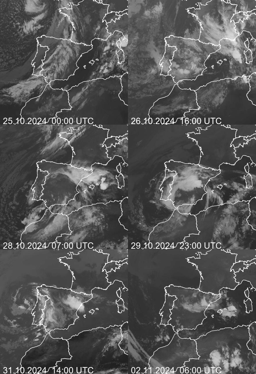
Sequence of hourly Meteosat images from 25/10/2024, 00 UTC, to 02/11/2024, 06 UTC (source: Berliner Wetterkarte)
Radiosonde soundings help with forecasting
The potential for the development of thunderstorms in the atmosphere is shown by the measurements taken during radiosonde ascents, which are visualised in so-called temps The Skew T – log (p) diagram illustrates the temperature (red line) and humidity (based on the dew point, green line) at different altitudes (pressure surfaces)
A warm, humid air parcel rising with the conditions on the ground cools down (to put it simply) as it rises according to the yellow line (pseudo-adiabatic); in the example, it therefore always remains warmer than the ambient air, whose temperature is represented by the red curve And thus continues to rise
The area between the two curves (marked in yellow) indicates the maximum potential energy available for convection ( CAPE = ‘Convective Available Potential Energy’) High CAPE values > 2000 J/kg indicate that an air parcel can be lifted very strongly If the ‘Lifted Index’ (LI) is clearly negative at the same time, indicating lability, severe thunderstorms are possible
For the Murcia station (WMO ID 08430), south of Valencia, the radiosonde ascent of 29 October 2024, 12 UTC, shows the unstable stratification of the atmosphere and the possible development of severe thunderstorms with hail (CAPE > 2000 j/kg and LI < -8 K)
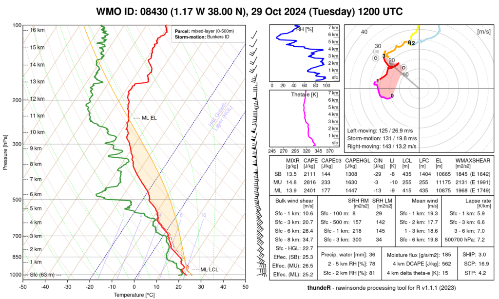
Radiosonde sounding, 29 October 2024, 12 UTC, Murcia station (WMO ID: 08430) (Data: AEMET)
Local heavy rain
The city of Utiel on the mostly low-water Rio Magro was particularly hard hit by heavy rain and thunderstorms on 29 October 2024, when the river became a torrent that made its way through the narrow city centre streets, piling cars on top of each other like toys. 207 l/m2 in 24 hours were recorded here.
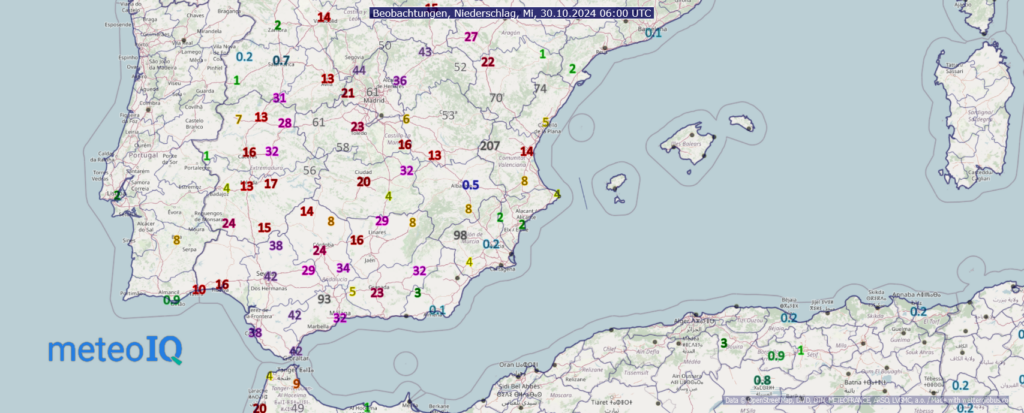
24-hour precipitation amount, 29/10/2024, 06 UTC – 30/10/2024, 06 UTC (Data: AEMET)
Accumulated precipitation
According to the Spanish weather service AEMET (Agencia Estatal de Meteorología), between 23 and 29 October 2024, 200 to 300l/m2 of precipitation was recorded in the east of Spain in some places. Locally, there were reports of more than 400 l/m2. This means that in some places, more than 300% of the rainfall normally expected in October fell in the affected regions.
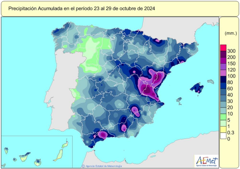
Accumulated precipitation from 23 to 29 October 2024 (Source: Spanish Weather Service, AEMET)
Precipitation continued in the western Mediterranean region at the turn of the month. Not only in parts of eastern Spain, but especially in Andalusia and Mallorca, around 100 l/m2 were added by 02/11/2024, 06 UTC.
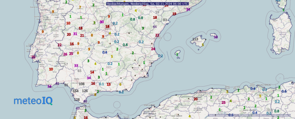
72-hour precipitation in l/m2 from 30/10/2024, 06 UTC to 02/11/2024, 06 UTC (source: AEMET)
Any time again?
Weather conditions like these occur more frequently in south-west Europe in autumn, but not always to this extent. Flooding after heavy rainfall in the area of a cold air drop in September 2019 with 200 to 400 l/m2 on 12 and 13 September 2019 was considered the heaviest in over 30 years. Five years later, this is now outdated.
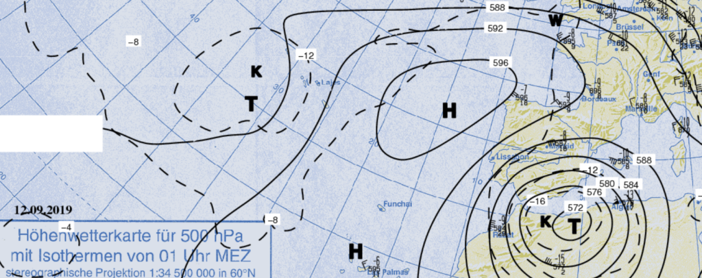
Cut-off low over the Alborán Sea, 500 hPa analysis map, 12/09/2019, 00 UTC (source: Berliner Wetterkarte)
With increasing warming of land and water and thus of the lower air layers in the summer months, such weather conditions are likely to become more frequent in autumn.
Support in the event of weather-related damage
You can use our MeteoArchive service to easily and flexibly call up information on precipitation and hail in the event of damage.
MeteoIQ supports insurance companies and insurance brokers in checking cover for weather-related damage caused by heavy rain, storms, lightning or hail in Germany and abroad.
Further information on our insurance services can be found at https://www.meteoiq.com/de/#insurance. We would be delighted if we could support you too.
